

Hydrochemical Evaluation of Saltwater Intrusion in Some Coastal Areas in Rivers State, Nigeria
- a University of Port Harcourt
Highlights
- Evaluated groundwater salinity and saltwater intrusion across six coastal communities in Rivers State, Nigeria.
- Analysed 12 groundwater samples for physicochemical parameters, major ions and selected heavy metals.
- Recorded salinity hotspots at Tema (3,810 mg/L), Sama (3,310 mg/L) and Ido (2,712 mg/L).
- Revealed substantial spatial variation in groundwater quality and sodium-related irrigation hazards.
- Recommended continuous hydrochemical monitoring, regulated groundwater abstraction and improved aquifer protection.
Abstract
This study evaluates the hydrochemical characteristics and extent of saltwater intrusion in selected coastal communities of Rivers State, Niger Delta, Nigeria, with particular emphasis on groundwater vulnerability, salinity distribution and suitability for domestic and agricultural applications. Groundwater samples were collected from six (6) boreholes and six(6) hand-dug wells across Sama, Tema, Abalama, Buguma, Ido and Obuama communities and analysed for physicochemical parameters, major ions and selected heavy metals using standard laboratory procedures. The results revealed considerable spatial variability in groundwater quality, with electrical conductivity (EC) ranging from 77 to 7,490 µS/cm and total dissolved solids (TDS) varying between 40 and 3,750 mg/L. Salinity concentrations were exceptionally elevated at Tema (3,810 mg/L), Sama (3,310 mg/L) and Ido (2,712 mg/L), exceeding the recommended drinking water threshold. Sodium concentrations also exceeded permissible limits at selected sampling locations, while elevated sodium adsorption ratios indicated potential irrigation constraints. Chloride-bicarbonate ratios ranged from 0.229 to 1.552, suggesting variable saline influence and localized hydrochemical modification. Spatial distribution maps further revealed heterogeneous salinization, reflecting interactions between coastal hydrodynamics, aquifer characteristics and anthropogenic activities. The findings establish that saltwater intrusion constitutes a significant threat to groundwater sustainability, necessitating continuous hydrochemical monitoring, regulated groundwater abstraction and appropriate aquifer protection strategies to safeguard potable water resources in the coastal Niger Delta.
Keywords
Introduction
Groundwater remains the most reliable source of
potable water in many coastal communities of Rivers State, Nigeria. With
increasing population growth, urbanization, and industrial activities, the
demand for groundwater has intensified, placing immense pressure on aquifer
systems. Coastal aquifers, however, are inherently vulnerable to saltwater
intrusion due to their proximity to tidal rivers and the Atlantic Ocean. The
delicate balance between freshwater and saline water, is easily disrupted when
groundwater extraction exceeds natural recharge or when sea level rise alters
hydraulic gradients. Empirical studies using electrical resistivity methods
have provided clear evidence of this vulnerability. In Bakana, resistivity
surveys revealed freshwater aquifers at depths of 13-200m, overlain by clay and
silty clay units, while shallow horizons exhibited low resistivity values
indicative of saltwater intrusion and possible hydrocarbon contamination
(Oghonyon et al., 2024). Similarly, investigations in Tombia, Degema LGA,
confirmed saline encroachment at depths of 20-40m and 82-95m, with freshwater
aquifers identified at deeper horizons of 140-175m (Dickenson et al., 2022).
These findings highlight a recurring pattern: shallow aquifers are highly susceptible to saline intrusion, while deeper aquifers, often confined by clay layers, remain relatively fresh and suitable for potable water supply. The implications of saltwater intrusion extend beyond hydrogeology to public health and socio‑economic development. Communities that rely on shallow wells and boreholes face increasing risks of consuming saline or contaminated water, which can lead to health challenges and reduced agricultural productivity. The situation is further compounded by anthropogenic activities such as poor waste disposal and industrial effluent discharge, which introduce additional contaminants into groundwater systems. The present study is focus on the salinity and contamination using hydrochemical parameters with selected metals and infer the degree of seawater mixing and contaminant loading in screened intervals and assess aquifer vulnerability and the risk to community water supplies by integrating hydrogeological setting, patterns, and contaminant distribution.
Materials and Methods
Study Area and Its Geology
The study
area is in Asari-Toru and Degema Local Government Area of Rivers State, Niger
Delta Southern Nigeria, which is located between latitudes 4˚ 46'21"N and
4˚22'00"N, and longitudes 4˚2'39"E and 7˚10'27"E. It is marked
by two distinct seasons, the dry season and the rainy season (Figure 1).
The dry
season lasts from about November to April and while the rainy season spans May
to October with a brief dry spell in August. The study area has characteristic
tropical equatorial climate with mean annual temperature of 32.8⁰C and annual
rainfall of 2673.8 mm. Located in Benin Formation, Asari-Toru and Degema is
typically riverine and has a large number of outlets through which her tributes
from River Niger empty their water into the Atlantic Ocean. It is predominantly
sandy with a few intercalations of shale beds. The sands are always
unconsolidated, granular in texture and characteristically fine to coarse
grained size and described as fresh water bearing. At various depths in the
formation, both confined and unconfined aquifers are encountered (Figure 1).
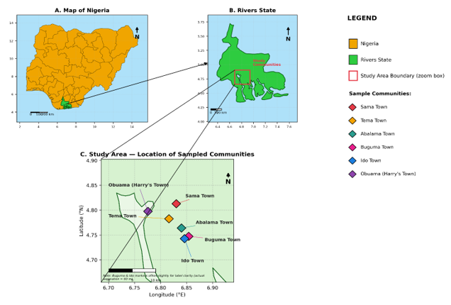
Figure 1: Map showing the study area
Geology and Hydro-geological Setting
In Rivers State, southern Nigeria, the
hydrogeology of the study area is
located within 4˚ 46'21"N and 4˚22'00"N, and longitudes 4˚2'39"E
and 7˚10'27"E. (Figure.1)., which includes Sama Town, Tema Town,
Abalama Community, Buguma Town, Ido Town, and Obuama Town, is fundamentally
controlled by the geologic framework, lithologic characteristics, climatic
conditions, and geomorphic setting of the eastern Niger Delta coastal plain.
This study area encompasses all of these towns. This region is located within the
Niger Delta Basin, which is a prolific sedimentary province that is
distinguished by thick accumulations of unconsolidated Quaternary to Recent
sediments. These sediments are responsible for the existence of large and
valuable groundwater systems. The intimate interplay between fluvial, deltaic,
and marine processes has a significant impact on the formation of aquifers,
groundwater flow regimes, and the distribution of water quality throughout the
region (Short and Stauble, 1967; Reijers et al., 1997).
It is the Benin Formation that serves
as the primary aquifer system that supports the towns of Sama, Tema, Abalama,
Buguma, Ido, and Obuama. The majority of this formation is made up of fine to
coarse grained sands and gravels that are either unconsolidated or weakly
consolidated, and it also contains clay and silt interbeds that are
subordinate. These interbeds were deposited in fluvial, floodplain, and upper
delta plain settings (Short and Stauble, 1967; Doust and Omatsola, 1990). In
most cases, the sandy units are well sorted, have a high concentration of
quartz, and are extremely porous. This results in a high groundwater storage
capacity and transmissivity. Studies conducted in the eastern part of the Niger
Delta have shown that the transmissivity values are typically high. This is a
reflection of the fact that the Benin Formation is dominated by permeable sandy
lithologies (Onuoha and Mbazi, 1988; Nwankwoala and Ngah, 2014).
Both unconfined and semi-confined
circumstances contribute to the presence of groundwater in the region under
investigation. In most cases, the shallow aquifer system is unconfined. This is
particularly true in the cities of Sama, Tema, Buguma, and Ido, where sandy
units stretch from the surface and the clay cover is either thin or discontinuous.
In contrast, the villages of Abalama and Obuama, which are located closer to
mangrove swamps and tidal creeks, display localised semi-confined conditions as
a result of the existence of peat layers, organic-rich mud, and silty clay with
a high concentration of organic matter. Perched or semi-confined aquifer
systems are created as a result of these layers, which function as
semi-constricting horizons that locally impede the transport of groundwater
into the vertical direction. A heterogeneity of this kind is typical of deltaic
aquifers, and it has been extensively described in hydrogeological
investigations that have been conducted in the Niger Delta in recent years
(Nwankwoala et al., 2020).
Recharge to the groundwater system is
predominantly received from the direct penetration of rainwater, which is
copious due to the humid tropical environment of the region. This is the
primary source of recharge. In addition to the high average annual rainfall,
the combination of a flat terrain, sandy soils that are permeable, and a short
depth to the water table makes it easier to effectively replenish the water
table. Additional recharge takes place as a result of the interaction between
surface water and groundwater, notably from rivers, tidal creeks, and plains
that are inundated yearly during high water stages. Reijers et al.,
(1997) and Oteri (2019) found that in locations that are prone to flooding,
protracted inundation and clayey surface layers might potentially impair
infiltration efficiency locally, even when there is a significant quantity of
rainfall.
Regional hydraulic gradients,
lithologic heterogeneity, and the dense network of surface water bodies all
have a role in determining the flow of groundwater within the area under
scientific investigation. It is common for groundwater to flow from interior
recharge zones toward coastal discharge regions, such as estuaries, tidal
creeks, and the Atlantic Ocean, when seen on a regional scale. As a result of
the effect of tidal variations, channel architecture, and heterogeneity within
the aquifer system, flow directions are extremely varied on a local level.
Onuoha and Mbazi (1988) and Oteri (2019) found that periodic tidal forcing can
cause short-term reversals in hydraulic gradients in coastal and estuarine
zones, which in turn promotes mixing between freshwater and saltwater water.
The depth of the water table in the
towns of Sama, Tema, Abalama, Buguma, Ido, and Obuama is often shallow,
typically ranging from less than one meter to a few meters below the surface of
the earth. This is especially true during the rainy season. There is a
significant amount of variation in groundwater levels throughout the year, with
water tables being recorded to be higher during times of extreme rainfall and
flooding, and seeing considerable drops during the dry season. Nwankwoala and
Udom (2011) found that oscillations like these have an effect on the mechanisms
of contaminant transport, the availability of groundwater, and the
susceptibility of aquifers to pollutants that are derived from the surface.
One of the most significant
hydrogeological challenges that the study region faces is the presence of
saline water incursion. Because of their proximity to the coast, low elevation,
and the strong hydraulic link that exists between aquifers and tidal water
bodies, freshwater aquifers are extremely vulnerable to the incursion of
saltwater. When protective clay layers are weak, fractured, or missing, saline
intrusion can occur laterally from tidal streams and estuaries or vertically
from deeper saline zones. This is especially true in situations when the clay
layers protect the soil. By decreasing freshwater heads and enabling salty
water to move inland, excessive groundwater extraction for residential and
industrial use might further worsen this problem (Oteri, 2019; Nwankwoala et
al., 2020). This problem can be further exacerbated by the depletion of
freshwater heads.
Recent research conducted in the
eastern Niger Delta has shed light on the growing effect of saline intrusion
and groundwater pollution, which are linked to fast population increase,
urbanisation, and activities connected to oil extraction (Etu-Efeotor and
Odigi, 2013; Nwankwoala et al., 2020). Because the aquifer system in
many sections of the study region is shallow and unconfined, groundwater is
especially susceptible to pollution from a variety of sources, including the
discharge of household waste, septic systems, hydrocarbon spills, and runoff
from agricultural land. According to Nwankwoala and Amadi (2013) and Adeoti et
al., (2021), investigations that are based on electrical resistivity have
been shown to be successful in identifying polluted zones, mapping
saline-freshwater interfaces, and characterising aquifer geometry in coastal
Niger Delta environments that are comparable.
Both natural and manmade variables have
an impact on the hydrogeochemical conditions that are present in the vicinity
of the research region. The chemistry of groundwater naturally reflects the
interaction of water and rocks inside sandy aquifers, the ion exchange
processes that include clay minerals, and the mixing of freshwater and
saltwater. An additional modification to the quality of groundwater is caused
by human activities, which leads to increased concentrations of dissolved solids,
chloride, and other toxins in some areas. (Adeoti et al., 2021) Recent
hydrogeochemical investigations in the state of Rivers have shown evidence of
geographic heterogeneity in groundwater quality. This variability is connected
to the closeness of the groundwater to streams, land use patterns, and the
depth of the aquifer.
Within the Benin Formation, the
hydrogeology of Sama Town, Tema Town, Abalama Community, Buguma Town, Ido Town,
and Obuama Town is characterised by groundwater systems that are abundant but
extremely susceptible. These groundwater systems are home to the Benin
Formation. The hydrogeological regime is characterised by high permeability,
shallow water tables, active interaction between surface water and groundwater,
and close proximity to the shore. Groundwater resources are normally abundant
and easily accessible; nevertheless, they are increasingly being endangered by
saline intrusion and pollution than they were previously. When it comes to
protecting coastal aquifers in the eastern Niger Delta area, these features
highlight the need of conducting integrated hydrogeological and geophysical
research, continuously monitoring groundwater, and managing water resources in
a sustainable manner. Lithostratigraphically,
these rocks are divided into the oldest Akata Formation (Paleocene), the Agbada
Formation (Eocene) and the Youngest Benin Formation (Miocene to Recent).
Generally, the present knowledge of the geology of the Niger Delta was derived
from the works of the following researchers (Reyment, 1965; Short &
Stauble, 1967; Murat, 1970; Merki, 1970) as well as the exploration activities
of the oil and gas companies in Nigeria. The formation of the so called
proto-Niger Delta occurred during the second depositional cycle
(Campanian-Maastrichtian) of the southern Nigerian basin. However, the modern
Niger Delta was formed during the third and last depositional cycle of the
southern Nigerian basin which started in the Paleocene. The geologic sequence
of the Niger Delta consists of three main Tertiary subsurface
lithostratigraphic units (Short & Stauble, 1967) which are overlain by
various types of Quaternary deposits (Table 1).
The major
aquiferous formation in the study area is the Benin Formation. It is about
2100m thick at the basin centre and consists of coarse-medium grained
sandstones, thick shales and gravels. The upper section of the Benin Formation
is the quaternary deposits which is about 40 – 150m thick and comprises of sand
and silt/clay with the later becoming increasingly more prominent seawards
(Etu-Efeotor & Akpokodje, 1990). The formation consists of predominantly
freshwater continental, friable sands and gravel that have excellent aquifer
properties with occasional intercalations of claystone/shales (Olobaniyi &
Oweyemi, 2006). According to Etu-Efeotor (1981), Etu-Efeotor & Akpokodje
(1990), Offodile (2002), Udom et al., (2002), the main source of
recharge is through direct precipitation where annual rainfall is as high as
2000 – 2400mm. The water infiltrates through the highly permeable sands of the
Benin Formation to recharge the aquifers. Groundwater in the study area occurs
principally under water table conditions. Multi-aquifer systems occur in the
study area and the upper aquifers are generally unconfined (EtuEfeotor, 1981;
Offodile, 2002; Amadi, 2004; and Udom, 2004).
Table 1: Quaternary deposits of the Niger Delta (after Etu-Efeotor & Akpokodje, 1990)
|
Geologic
Unit |
Lithology
Age |
Age |
|
Alluvium
Gravel |
Sand,
clay, silt |
|
|
Freshwater
Backswamp, meander |
Sand,
clay, some silt, gravel |
|
|
Saltwater
Mangrove Swamp and backswamp |
Medium-fine
sands, clay and some silt |
Quaternary
|
|
Active/abandoned
beach ridges |
Sand,
clay, and some silt |
|
|
Sombreiro-warri
deltaic plain |
Sand,
clay, and some silt |
|
Data
Collection Procedure
Groundwater
samples were collected from 6 (six) boreholes and 6(six) hand dug well after 5
minutes of pumping to ensure the samples were true representative from the
aquifer. The samples were stored in sterilized two-litre containers with
tightly fitting covers wrapped in a black polyethylene plastic bag and put in a
cooler to ensure constant temperature. The containers were first washed with
de-ionized water, and then several times with the sample water before
collection in order to avoid any contamination. Parameters like pH and
temperature and electrical conductivity were determined in the field due to
their unstable nature. The pH of the water sample was measured with a pH meter.
The glass tube in the kit was sterilized before been filled to its mark with
water sample. The tube was then placed in the space provided in the equipment
and a knob adjusted for colour matching, the pH was then read and recorded. The
temperature was read using a mercury thermometer. The electrical conductivity
was measured using a Mark electronic switchgear conductivity meter. After
sampling, the lids of the containers were immediately replaced to minimize
contamination and escape of gases. The samples were then stored in an
ice-packed cooler for analysis within 24 hours. All analyses were carried out
at a standardized laboratory using national and international regulatory
methods. The evaluation of water quality was in accordance with regulatory
standard. The approach ensures that the samples collected were tested in
accordance with agreed requirements using competent personnel as well as
appropriate equipment and materials. Figure.1, is the map showing sampling
locations.
Analysing saltwater intrusion in
coastal area involved hydrogeological and geochemical at various locations (see
Figure 1) around the study area. Water samples were collected and analysed for
(i) pH, (ii) Electrical Conductivity, (iii) Chlorides, (iv) Bicarbonates, (v) Calcium,
(vi) Sodium, (vii) Magnesium, (viii) Sulphates, (ix) Total Hardness and (x)
Total Dissolved Solids, using standard water quality assessment (APHA, 1989)
methods. argentometric titration using standard silver nitrate solution.
Sulphate (SO₄²⁻) was analysed by the turbidimetric method using a
UV–Visible spectrophotometer, while bicarbonate (HCO₃⁻) was
determined by acid titration Nitrate (NO₃⁻) concentrations were
measured spectrophotometrically following Standard Methods for the Examination
of Water and Wastewater.
Heavy Metal Analysis
Groundwater samples were digested using
concentrated nitric acid according to APHA standard procedures. Iron (Fe),
manganese (Mn), lead (Pb), cadmium (Cd), chromium (Cr), nickel (Ni), copper
(Cu), and zinc (Zn) were quantified using Flame Atomic Absorption
Spectrophotometry. Calibration curves were prepared from certified standard
solutions, while reagent blanks, duplicate samples, and certified reference
materials were analysed simultaneously to ensure analytical accuracy and
precision.
Results and Discussion
Physico-Chemical
Parameters of the Study Area
The analytical results for groundwater
samples from study area are presented in Table 2. reveal a dataset dominated by
strong positive skewness, reflecting the coexistence of minimally impacted
wells and heavily mineralized boreholes within the same coastal corridor.
Temperature was essentially invariant (mean 28.18 ± 0.45 °C; CV = 1.6%), There
is no standard value recommended for groundwater temperature by the WHO (2006),
consistent with equatorial shallow aquifer conditions, whereas EC and TDS
exhibited the highest dispersion in the dataset (EC: 77-7,490 µS/cm, CV = 132%;
TDS: 40-3,750 mg/L, CV = 148%), confirming the spatially heterogeneous
salinization documented for the Niger Delta coastal belt (Eyankware et al.,
2021; Udota et al., 2022). Mean pH (6.57 ± 0.49) was marginally acidic
and within the 6.5-8.5 window recommended for irrigation (Ayers & Westcot,
1985), although BH5 (Ido, 5.37) fell below it. Sodium (121.12 ± 110.95 mg/L; CV
= 92%) and chloride (96.70 ± 42.20 mg/L) displayed wide ranges with three Na
exceedances of the NSDWQ (2007) limit.
Table 2:The Physico-Chemical parameters
|
S/N |
Parameter |
BH1 |
WELL1 |
BH2 |
WELL2 |
BH3 |
WELL3 Abalama |
BH4 |
WELL4 |
BH5 |
WELL5 |
BH6 |
WELL6 |
WHO |
NSDWQ |
|
Latitude |
4°48'46"N |
4°48'46"N |
4°48'46"N |
4°46'57"N |
4°46'57"N |
4°45'50"N |
4°45'50"N |
4°44'41"N |
4°44'41"N |
4°44'42"N |
4°44'42"N |
4°47'51"N |
|
||
|
Longitude |
6°49'49"E |
6°49'49"E |
6°49'49"E |
6°48'59"E |
6°48'59"E |
6°50'25"E |
6°50'25"E |
6°51'02"E |
6°51'02"E |
6°50'59"E |
6°50'59"E |
6°46'33"E |
|
||
|
Elevation |
20m |
20m |
20m |
13m |
13m |
10m |
10m |
0m |
0m |
0m |
0m |
10m |
|||
|
1 |
Temp. |
28.3 |
28.5 |
28.4 |
27.8 |
29.2 |
27.8 |
28.3 |
28.1 |
28.3 |
27.7 |
27.5 |
28.2 |
NS |
NS |
|
2 |
EC |
6530 |
229 |
77 |
7490 |
529 |
596 |
1120 |
428 |
985.8 |
897.6 |
3763 |
596 |
NS |
<1000 |
|
3 |
pH |
6.39 |
6.65 |
6.26 |
6.44 |
7.09 |
6.92 |
7.01 |
6.99 |
5.37 |
6.17 |
6.66 |
6.92 |
6.5–8.5 |
|
|
4 |
TDS |
3270 |
114 |
40 |
3750 |
50 |
296 |
559 |
214 |
50 |
43 |
2733 |
296 |
<1000 |
<500 |
|
5 |
Salinity |
3310 |
114 |
40 |
3810 |
50 |
298 |
556 |
215 |
50 |
44 |
2712 |
298 |
NS |
<500 |
|
6 |
Sodium |
242.7 |
36.3 |
24.75 |
365 |
88.6 |
97.3 |
189.8 |
78.8 |
20.5 |
55.7 |
232 |
22 |
<200 |
<200 |
|
7 |
Calcium |
6.07 |
3.84 |
6.75 |
6.88 |
5.54 |
2.03 |
9.33 |
8.63 |
6.87 |
5.73 |
4.78 |
8.45 |
NS |
<75 |
|
8 |
Magnesium |
2.24 |
6.65 |
5.76 |
4.62 |
4.64 |
8.63 |
6.87 |
6.92 |
5.77 |
5.76 |
7.32 |
4.42 |
NS |
<50 |
|
9 |
Sulphate |
23.74 |
67.77 |
26.72 |
8.98 |
23.22 |
24.03 |
91.33 |
84.63 |
60.87 |
65.73 |
53.77 |
72.78 |
<250 |
<100 |
|
10 |
Nitrate |
2.03 |
9.33 |
8.63 |
6.87 |
5.73 |
9.76 |
8.23 |
7.34 |
4.66 |
6.74 |
5.76 |
4.43 |
<50 |
<50 |
|
11 |
Chloride |
147.63 |
86.68 |
103.87 |
146.85 |
25.7 |
56.33 |
103.5 |
50.67 |
112.7 |
127.9 |
145.4 |
53.22 |
<250 |
<250 |
|
12 |
Bicarbonate |
103.36 |
88.8 |
84.22 |
121.58 |
112.02 |
238.7 |
123.5 |
98.2 |
83.9 |
89.8 |
93.7 |
66.7 |
NS |
NS |
|
13 |
Iron |
0.22 |
0.46 |
0.42 |
0.19 |
0.44 |
0.32 |
0.29 |
0.3 |
0.42 |
0.53 |
0.31 |
0.44 |
<0.3 |
<0.3 |
|
14 |
Nickel |
BDL |
BDL |
BDL |
BDL |
BDL |
BDL |
BDL |
BDL |
BDL |
BDL |
BDL |
BDL |
<0.02 |
<0.02 |
|
15 |
Cadmium |
0.001 |
0.0001 |
0.0001 |
BDL |
BDL |
BDL |
BDL |
BDL |
BDL |
BDL |
BDL |
BDL |
<0.003 |
|
|
16 |
Copper |
BDL |
0.32 |
0.65 |
0.32 |
BDL |
BDL |
BDL |
BDL |
BDL |
BDL |
BDL |
BDL |
<1.0 |
<1.0 |
|
17 |
Potassium |
5.03 |
6.21 |
4.74 |
7.73 |
6.22 |
6.65 |
5.34 |
6.33 |
3.23 |
2.43 |
3.67 |
3.44 |
NS |
<12 |
|
18 |
Lead |
BDL |
BDL |
BDL |
BDL |
BDL |
BDL |
BDL |
BDL |
BDL |
BDL |
BDL |
BDL |
<0.01 |
<0.01 |
|
19 |
BOD |
5.12 |
1.43 |
0.87 |
6.22 |
2.7 |
2.91 |
3.24 |
1.23 |
0.65 |
1.72 |
4.67 |
0.23 |
NS |
NS |
|
20 |
COD |
10.3 |
2.5 |
1.72 |
13 |
6.3 |
3.3 |
5.93 |
3.22 |
1.12 |
3.44 |
9.98 |
2.23 |
NS |
<10 |
|
†|
SAR |
21.38 |
2.6 |
1.69 |
26.38 |
6.71 |
6.64 |
11.49 |
4.84 |
1.39 |
3.93 |
15.56 |
1.53 |
<10 |
NS |
All parameters are in
mg/L except Temp-oC and Electrical Conductivity (EC)- µS/cm
Table 2
shows the hydrochemical characteristics of groundwater samples indicate direct
geochemical interpretation of contamination of the coastal environment. The
analyzed parameters show that the groundwater chemistry is dominated by high
ionic concentrations typical for saline or under the influence of contamination
sudden mineralized water conditions, electrical conductivity and total
dissolved solids are more in line with conditions of the mineralized water than
pure fresh water. The relative abundance of major cations and anions is indicated
in active water sediment interaction among unconsolidated coastal sediments and
indicates more influx of saline and anthropogenic influences. Elevated chloride
concentrations with respect to bicarbonate are certainly notable, being
indicative of marine- or saline contaminating processes with water, rather than
only meteoric recharge, whilst equivalent sodium enrichment is indicative of
ion exchange processes, commonly found in coastal aquifer system cases of
contamination or salinization. The pH values for Table 2 range from slightly
acidic to near-neutral, which is in the general range of water which has passed
through clayey and silty coastal deposits and agrees with the geoelectrical
identification of conductive horizons interpreted as contamination or saline
fronts. One can see the presence and relative calcium and magnesium content is
also providing evidence for dissolution of sedimentary material and the
possible mixing of fresh and salty water, which further supports the
interpretation of a disturbed hydrochemical regime. Where nitrate and sulphate
are elevated, their occurrence is consistent with surface derived sources of
contamination such as domestic waste, agricultural runoff or lagoonal backflow,
which are common in low lying coastal communities of the ground water is
affected by contamination or saline intrusion. Table 2 confirms the fact that
the quality of ground water in the study area is highly affected by the coastal
processes and contamination pathways, thus confirming that saline intrusion and
anthropogenic contamination is a major threat to ground water sustainability in
the area.
The
spatial distribution of groundwater salinity across the study area reveals a
markedly heterogeneous contamination regime, with discrete thermal like
hotspots of extreme ionic enrichment that substantially transgress the Nigerian
Standard for Drinking Water Quality (NSDWQ, 2007) threshold of <500 mg/L.
The most pronounced salinity anomalies are concentrated at Tema (Well 2: 3,810
mg/L), Sama (BH1: 3,310 mg/L), and Ido (BH6: 2,712 mg/L), which collectively
define a bifocal plume architecture exceeding the regulatory limit by factors
of 5.4 to 7.6 (Figure 2). These extreme
values are diagnostic of active saltwater intrusion or anthropogenic saline
loading, consistent with regional findings that coastal aquifers of the Niger
Delta Benin Formation exhibit low longitudinal conductance and high
vulnerability to salinization due to permeable overburden and proximity to
marine interfaces (Nkpoidet et al., 2025). By contrast, samples from
Sama (BH2: 40 mg/L; Well 1: 114 mg/L), Tema (BH3: 50 mg/L), and Buguma (BH5: 50
mg/L) register salinity well within the NSDWQ potable envelope, underscoring
extreme spatial heterogeneity at the intra community scale (Table 2 and 3).
The
spatial gradient manifests a distinct NW-SE vector of increasing salinity, with
the highest conductometric signatures clustering around low-elevation coastal
settlements (Buguma and Ido at 0 m elevation) and extending inland toward Tema
and Sama. This topographically controlled distribution corroborates time-lapse
electrical resistivity investigations that document active lateral salinity
changes rapidly intruding freshwater aquifers in southeastern Niger Delta
coastal environments (Inim et al., 2020). Notably, the elevated salinity
values coincide with high electrical conductivity and total dissolved solids,
forming a coherent hydrochemical facies indicative of Na-Cl dominance driven by
seawater mixing or evaporite dissolution (Omajene et al., 2024). The
NSDWQ (2007) threshold, although not exceeded in all sampling points, is
breached at four distinct locations, signifying that approximately one third of
the monitored aquifer units are already compromised. The concentration map thus
captures a transitional hydrogeological state wherein fragmented freshwater
lenses are progressively assimilated by encroaching conductive fronts,
necessitating immediate aquifer vulnerability assessment and regulated
extraction to avert total potable collapse (Nkpoidet et al., 2025).
Table 3: Key
Observations from the Map
|
Zone |
Salinity Range |
Status |
|
Tema
(Well 2) |
~3,810
mg/L |
Severely
contaminated — exceeds NSDWQ limit by 7× |
|
Sama
(BH1) |
~3,310
mg/L |
Severely
contaminated — exceeds NSDWQ limit by 6.6× |
|
Ido
(BH6) |
~2,712
mg/L |
Highly
contaminated— exceeds NSDWQ limit by 5.4× |
|
Abalama
(BH4) |
~556
mg/L |
Marginally
above NSDWQ (<500 mg/L) |
|
Obuama,
Buguma, Abalama (Well) |
<300
mg/L |
Within
acceptable range |
|
Sama
(BH2, Well 1), Tema (BH3) |
40–114
mg/L |
Pristine/fresh |
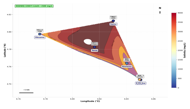
Figure 2: Spatial distribution of Groundwater Salinity Concentration Map
The spatial distribution of hydrochemical parameters across the study area reveals a tripartite zonation reflecting differential contamination vectors and aquifer vulnerability within the Niger Delta Benin Formation (Figure 3). The Northwest cluster (Obuama) registers consistently moderate signatures, with Well 6 exhibiting electrical conductivity (596 µS/cm), total dissolved solids (296 mg/L), and salinity (298 mg/L) within or marginally approaching potable thresholds, alongside a low sodium adsorption ratio (SAR = 1.53), indicating minimal sodium hazard. This cluster represents the least compromised hydrogeological regime, likely benefiting from greater topographic elevation (10 m) and distance from saline intrusion fronts.
The
Central cluster (Tema-Abalama) manifests extreme spatial
bifurcation, a hallmark of point-source contamination superimposed on regional
salinization. Tema Well 2 registers the most severe deterioration across all
parameters (EC 7,490 µS/cm; TDS 3,750 mg/L; salinity 3,810 mg/L; Na⁺ 365 mg/L;
SAR 26.38), exceeding NSDWQ (2007) limits by an order of magnitude, whereas
adjacent BH3 maintains pristine conditions (EC 529 µS/cm; TDS 50 mg/L). This
intra community disparity is consistent with hydrochemical investigations
documenting that Na-Cl facies in the Niger Delta arise from both saltwater
intrusion and anthropogenic effluent discharge, with spatial heterogeneity
driven by preferential flow pathways and differential aquifer confinement (Odesa 2024).
Abalama exhibits intermediate degradation (BH4: EC 1,120 µS/cm; salinity 556
mg/L), suggesting progressive plume encroachment (Table 3).
The
Southeast cluster (Buguma-Ido) at 0 m elevation
demonstrates coastal aquifer vulnerability, with Ido BH6 registering elevated
TDS (2,733 mg/L), salinity (2,712 mg/L), and SAR (15.56), indicative of
density-driven saltwater intrusion. Buguma remains comparatively moderate,
though BH5 exhibits anomalous EC (985.8 µS/cm) despite low TDS, possibly
reflecting conductive ionic species from surficial contamination. The
collective spatial gradient intensifying from northwest to southeast
corroborates regional models attributing coastal groundwater degradation to
marine intrusion exacerbated by low topographic relief and excessive extraction
(Hagage et al.,
2024).
The tripartite zonation thus captures a continuum from relatively protected
inland reserves to actively salinizing coastal aquifers.
The
spatial distribution of the Irrigation Water Quality Index (IWQI) across the
study area delineates a pronounced hydrogeochemical mosaic, reflecting
differential aquifer vulnerability and anthropogenic loading within the Niger
Delta coastal Formation. The severely compromised zones
are concentrated at Tema (Well 2: IWQI 38.0
Very Poor) and Sama (BH1: IWQI 45.4 Poor), where extreme electrical
conductivity (>6,500 µS/cm) and sodium adsorption ratios exceeding 20
collectively indicate acute salinity and sodium hazards (Figure 4). These parameters exceed the critical
thresholds where SAR >10 and EC >3,000 µS/cm trigger severe soil
permeability degradation and osmotic stress, rendering the water unsuitable for
most crop types (Agidi et
al., 2026). The elevated Na⁺ percentages (>94%)
at these points suggest reverse ion exchange processes, wherein sodium
displaces calcium and magnesium on clay matrices, a phenomenon well documented
in coastal aquifers subjected to saltwater intrusion and anthropogenic effluent
discharge (Egbueri et al.,
2025).
Conversely, pristine zones are identified at Sama (BH2: IWQI 90.4; Well 1: IWQI 88.6) and Obuama (Well 6: IWQI 87.8), all classified as Excellent.
These samples register SAR values <3, EC <250 µS/cm, and Na% <70,
satisfying the stringent criteria for unrestricted irrigation use where water
can be applied to sensitive crops without soil structural deterioration. (Meireles et al.,
2024).
The spatial gradient manifests a northwest to southeast
deterioration vector, with inland elevated communities (Sama at 20 m, Obuama at
10 m) maintaining superior quality, while coastal low-elevation towns (Buguma,
Ido at 0 m) exhibit intermediate to fair classifications. This pattern
corroborates regional hydrogeochemical models attributing coastal groundwater
degradation to marine intrusion exacerbated by topographic relief and excessive
extraction. (Sylvester,
2023).
Most
critically, intra community disparity is starkly evident within Sama,
where BH1 (Poor) and BH2 (Excellent) exhibit a 45point IWQI differential over
minimal spatial separation. This bifurcation indicates highl contamination
vectors likely artisanal drilling conduits or fracture driven preferential flow
rather than diffuse regional salinization, necessitating borehole specific
remediation strategies rather than blanket administrative interventions.
The geospatial distribution of sodium
and chloride across the six coastal communities delineates a salinization
gradient that is strongly conditioned by proximity to tidal conduits and
shoreline position. Sodium concentrations exceed the NSDWQ (2007) permissible
limit of 200 mg/L at BH1 (Sama, 242.7 mg/L), BH2 (Tema, 365 mg/L) and Well 6 (Ido,
232 mg/L), with the two former sites occupying the western, ocean-facing and
river-channel axis through which Atlantic water propagates during tidal
flooding. This spatial correspondence is consistent with the landward salt influx
mechanism documented for the Niger Delta by Abam (2001) and empirically imaged
at Okrika and Bonny by Abija et al., (2021) and Udota et al.,
(2022). Chloride, although below the 250 mg/L threshold at all stations,
exhibits a coherent eastward elevating band (112-148 mg/L) tracking the tidal
creek system, while the most inland station (Obuama) records the lowest values
a distance decay pattern diagnostic of marine influence.
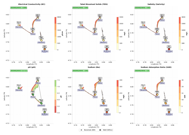
Figure 3: Comprehensive Spatial Distribution Map of hydrochemical parameters across the study area
Table 3: Spatial interpolation of critical hydrochemical parameters
|
Panel |
Parameter |
NSDWQ/WHO Threshold |
Key Observations |
|
(a) |
Electrical Conductivity
(EC) |
<1000 µS/cm |
Extreme hotspots at Tema
Well 2 (7,490) and Sama BH1 (6,530), indicating severe ionic enrichment |
|
(b) |
Total Dissolved Solids
(TDS) |
<500 mg/L |
Sama BH1 (3,270, Tema
Well 2 (3,750), and Ido BH6 (2,733) exceed limits by 5–7.5 |
|
(c) |
Salinity |
<500 mg/L |
Same hotspots as TDS;
Buguma BH5 (50) and Sama BH2 (40) remain pristine |
|
(d) |
pH |
6.5–8.5 |
Buguma BH5 (5.37) is
strongly acidic; most other samples fall within acceptable range |
|
(e) |
Sodium (Na⁺) |
<200 mg/L |
Tema Well 2 (365) and
Sama BH1 (242.7) breach the threshold, consistent with Na-Cl facies |
|
(f) |
Sodium Adsorption Ratio
(SAR) |
<10 |
Sama BH1 (21.38 Tema Well
2 (26.38), and Ido BH6 (15.56) indicate high sodium hazard for irrigation |
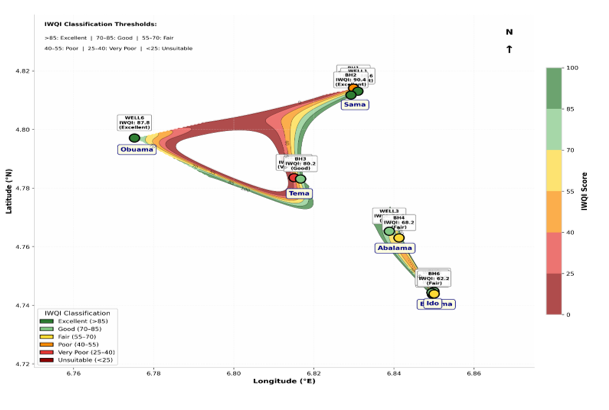
Figure 4: Spatial Distribution Map of Irrigation Water Quality Index (IWQI)
Critically, the decoupled high-chloride/low-sodium signature at BH4 (Buguma; Cl = 112.7 mg/L, Na = 20.5 mg/L) departs from the coupled Na-Cl enrichment expected of seawater mixing (Na⁺/Cl⁻ ≈ 0.86), implying a non-marine chloride source such as connate brackish water, mineral leaching, or anthropogenic input (Giadom et al., 2022). The anomously high sodium at Well 6 relatives to its paired borehole (BH5) further suggests localized well specific contamination rather than regional intrusion. Collectively, the dataset indicates spatially heterogeneous salinization in which active tidal intrusion, paleo-saline beds and point source pollution interact, underscoring the necessity of ionic ratio and isotopic verification before ascribing salinity to seawater intrusion alone (Figure 5).
Geochemical
Interpretation of Saltwater Intrusion
Chloride is
the dominant ion in seawater and it is only available in small quantities in
groundwater. While Bicarbonate which is available in large quantities in
groundwater occurs only in very small quantities in seawater (Raghunath, 1990).
It has been found that a chloride/bicarbonate ratio greater than 2 is
indicative of saltwater intrusion (Revelle, 1941).
The
following equation is used to evaluate the degree of salinization:
x/35.46 > 2 indicates intrusion
y/61.02
Where x is
chloride concentration in mg/l
y is bicarbonate concentration in mg/l
35.46 molecular mass of chlorine
61.02 molecular mass of bicarbonate
From Figure 6-8, delineates the spatial distribution of electrical conductivity (EC) across Sama, Tema, Abalama, Buguma, Ido and Obuama, using 1000 µS/cm as the threshold separating freshwater from saline-influenced groundwater (Standard Organisation of Nigeria, 2015). Sama and Tema plot within the saline domain, with EC values reaching 6530 and 7490 µS/cm respectively, indicating pronounced marine influence consistent with seawater intrusion (Werner, 2013). Paired boreholes and wells at these locations differ markedly, for instance Tema, where values range from 77 to 7490 µS/cm, signifying vertical heterogeneity in salinity within the aquifer (Todd and Mays, 2005). Abalama records 428 and 1120 µS/cm, placing it near the provisional transition line, whereas the Ido and Buguma cluster, close to 988.8 µS/cm, straddles the boundary. Obuama, positioned westward, remains below the threshold. Collectively, the pattern shows that salinity is controlled by proximity to saline sources and local hydrogeological conditions rather than by simple lateral gradients across the delta (Appelo and Postma, 2005).
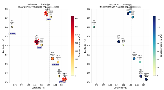
Figure 5: Geospatial distribution of sodium and Chlorine
Table 4: Showing location of monitoring
wells, Chloride/Bicarbonate Ratio and Distance from Shoreline
|
Site |
Chloride mgL |
Bicarbonate mgL |
Cl-HCO3ratio |
Distance from Obuama km |
|
Sama BH1 |
147.63 |
103.36 |
1.428 |
6.274 |
|
Sama Well 1 |
86.68 |
88.8 |
0.976 |
6.274 |
|
Sama BH2 |
103.87 |
84.22 |
1.233 |
6.274 |
|
Tema Well 2 |
146.85 |
121.58 |
1.208 |
4.799 |
|
Tema BH3 |
25.7 |
112.02 |
0.229 |
4.799 |
|
Abalama Well 3 |
56.33 |
238.7 |
0.236 |
8.069 |
|
Abalama BH4 |
103.5 |
123.5 |
0.838 |
8.069 |
|
Buguma Well 4 |
50.67 |
98.2 |
0.516 |
10.16 |
|
Buguma BH5 |
112.7 |
83.9 |
1.343 |
10.16 |
|
Ido Well 5 |
127.9 |
89.8 |
1.424 |
10.067 |
|
Ido BH6 |
145.4 |
93.7 |
1.552 |
10.067 |
|
Obuama |
53.22 |
66.7 |
0.798 |
0 |
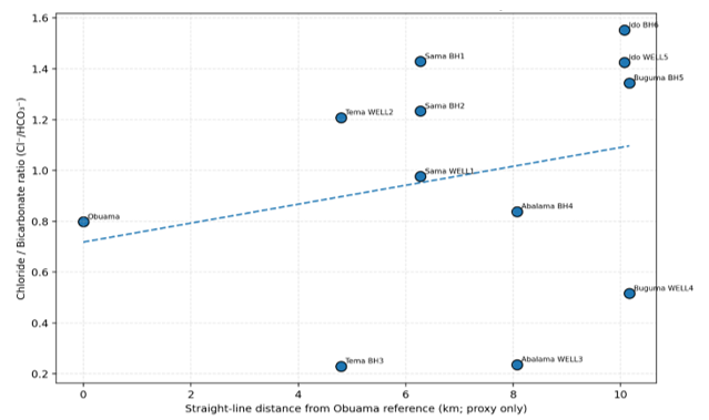
Figure 6 Shows decreasing Chloride-Bicarbonate ratio with increasing distance from shoreline indicating high salinization near the shore.
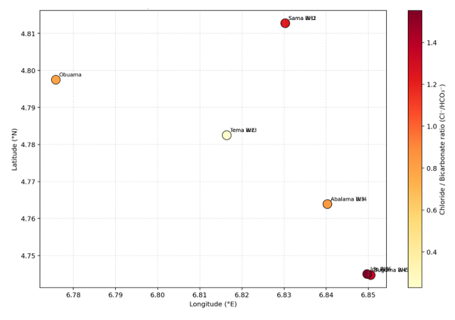
Figure 7: Spatial distribution of Chloride-Biocarbonate Ratio hydrochemical salinization indicator
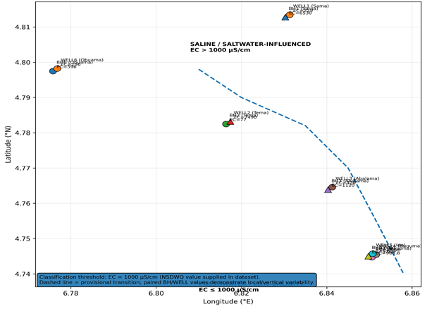
Figure 8: freshwater-saltwater/saline influence boundary map
Irrigation Suitability
Sama BH1 is a typical Na-Cl water with a very high
salinity hazard and an extreme sodium adsorption ratio (SAR) of 21.4. This
combination renders it unsuitable for irrigation, since excess sodium displaces
calcium and magnesium on soil exchange sites, degrading soil structure, while
elevated salinity imposes osmotic stress on crops (Richards, 1954; Ayers and
Westcot, 1985). Sama Well 1 is also Na-Cl but considerably less hazardous, with
low salinity and an SAR of 2.59. However, its high magnesium hazard (74.1%) may
promote soil hardening and reduced productivity (Szabolcs and Darab, 1964).
Tema BH2 shares the Na-Cl facies, with low
salinity hazard and an SAR of 1.69, although a magnesium hazard above 50%
warrants caution. In contrast, Tema Well 2 exhibits very high salinity hazard
and an SAR of 26.4, indicating a pronounced sodium hazard and unsuitability for
most crops. Abalama BH3 and Well 3, both Na-HCO₃ types, show medium salinity
hazard and SAR values of about 6.7. They are therefore borderline, because
bicarbonate dominance favours the precipitation of calcium and magnesium
carbonates, leaving sodium proportionally more active in the soil solution
(Appelo and Postma, 2005). The magnesium hazard of Abalama Well 3 (87.5%) is
especially problematic. Buguma BH4 (Na-Cl) combines high salinity hazard with
an SAR of 11.5, making it unsuitable for salt-sensitive crops, whereas Buguma
Well 4 (Na-SO₄) is milder, with medium salinity hazard and an SAR of 4.84,
though its magnesium hazard remains above 50%. Ido BH5 and Well 5 are both
Na-Cl waters with high salinity hazard. Their SAR values are low (1.39 and
3.92), but magnesium hazards exceeding 58% sustain the risk of soil alkalinity
(Raghunath, 1987). Obuama BH6 is strongly saline, with very high salinity
hazard, an SAR of 15.6 and a magnesium hazard of 71.6%, characteristic of
brackish water unfit for irrigation. Obuama Well 4 (Na-SO₄) is comparatively
moderate, with medium salinity hazard, an SAR of 1.52 and a magnesium hazard
below 50%, and is thus relatively safer. Basically, Sama BH1, Tema Well 2 and
Obuama BH6 are unsuitable for irrigation because of very high salinity and
sodium hazards. The Abalama sources fall in the medium class but are
compromised by magnesium hazard, while Buguma and Ido waters pose high hazards
and require careful management. Only Sama Well 1, Tema BH2 and Obuama Well 4
show potential for limited irrigation, subject to magnesium related constraints
(Ayers and Westcot, 1985).
Hydrochemical
Assessment
Evaluation of groundwater chemistry against the
WHO (2022) guideline values reveals varying degrees of compliance and
exceedance, reflecting the influence of coastal contamination processes.
Cadmium, nickel and lead were assessed as priority toxic trace metals because of
their public health significance. Where concentrations exceed permissible
limits, they suggest anthropogenic inputs such as waste disposal, corrosion of
plumbing materials, or salinity driven mobilization from aquifer matrices (Hem,
1985). Even marginal exceedances are of concern because these metals
bioaccumulate and pose long-term health risks (WHO, 2022). Magnesium and
calcium concentrations generally reflect aquifer mineralogy and water rock
interaction. Elevated values indicate prolonged residence time and enhanced
dissolution of carbonate and silicate minerals, often intensified by saline
mixing (Appelo and Postma, 2005). Potassium normally occurs at low
concentrations in natural groundwater; elevated levels therefore point to
domestic effluents or agricultural inputs rather than geogenic sources (Hem,
1985). Sodium is a key indicator of coastal contamination. Concentrations
approaching or exceeding the WHO (2022) limit of 200 mg/l strongly suggest
saline intrusion or cation exchange, in which sodium displaces calcium and
magnesium on clay mineral surfaces (Werner 2013). This trend agrees with the
dominance of Na-Cl facies in the hydrochemical diagrams.
Finally, pH values largely within the WHO (2022)
range indicate near neutral conditions, although slight deviations reflect
geochemical reactions such as ion exchange and saline mixing. Electrical
conductivity values exceeding recommended limits confirm elevated ionic
strength, consistent with saline contamination and supported by the prevalence
of sodium and chloride across the study area (Todd and Mays, 2005).
Conclusion
This study has established
that groundwater resources within Sama, Tema, Abalama, Buguma, Ido and Obuama
communities of Rivers State exhibit considerable hydrochemical variability,
reflecting the combined influences of saltwater intrusion, lithological
interactions and anthropogenic contamination. The observed electrical
conductivity values (77-7,490 µS/cm), total dissolved solids (40-3,750 mg/L)
and salinity concentrations demonstrate pronounced spatial heterogeneity in
aquifer conditions. Tema, Sama and Ido emerged as the most significantly
affected locations, with salinity levels substantially exceeding recommended
drinking-water standards, thereby indicating potential deterioration of groundwater
quality. Furthermore, elevated sodium concentrations and sodium adsorption
ratios at selected sampling points underscore the associated limitations for
agricultural utilization. The chloride-bicarbonate ratios provide additional
evidence of variable saline influence, although their values suggest that
saltwater intrusion cannot be regarded as the sole determinant of groundwater
mineralization. The spatial distribution of hydrochemical parameters further
demonstrates that localized aquifer characteristics and preferential
contaminant migration pathways influence groundwater vulnerability.
Consequently, sustainable groundwater management requires systematic
hydrochemical surveillance, controlled abstraction, improved waste disposal
practices and periodic assessment of coastal aquifer conditions. Ultimately,
integrating hydrochemical investigations with geophysical monitoring is
essential for identifying saline interfaces, protecting vulnerable freshwater
reserves and ensuring the long-term availability of safe groundwater throughout
the coastal Niger Delta.
Declaration
of Competing Interest
The
authors declare that they have no known competing financial interests or
personal relationships that could have appeared to influence the work reported
in this paper.
References
Abam, T. K. S. (2001). Regional hydrological research perspectives in the Niger Delta. Hydrological Sciences Journal, 46(1), 13–25.
Abija, F. A., Marshall, H. I., & Udom, G. J. (2021). Sources of Salinization and Investigation of Salt Water Intrusion into Coastal Aquifers in Parts of the Niger Delta, Nigeria. Journal of Hydrogeology & Hydrologic Engineering. SciTechnol
Adeoti, L., Ezeh, N., & Ogundipe, O. (2021). Hydrogeochemical assessment of coastal aquifers in the Niger Delta, Nigeria. Journal of African Earth Sciences, 179, 104229. https://doi.org/10.1016/j.jafrearsci.2021.104229
Agidi L.E., (2026). Hydrogeochemical assessment of water from selected communities in the Niger Delta Region. Discover Applied Sciences. https://doi.org/10.1007/s43832-025-00335-6
Amadi P.A. (2004). Groundwater resources of Port Harcourt and its environs. Unpublished PhD Thesis, Nnamdi Azikiwe University, Awka, Nigeria. 394p. Udom, 2004).
American Public Health Association, American Water Works Association, & Water Pollution Control Federation. (1989). Standard methods for the examination of water and wastewater (17th ed.). American Public Health Association.
Appelo, C. A. J., & Postma, D. (2005). Geochemistry, groundwater and pollution (2nd ed.). CRC Press.
Ayers, R. S., & Westcot, D. W. (1985). Water quality for agriculture (FAO Irrigation and Drainage Paper 29). FAO.
Dickenson, H. D., Oghonyon, R., Itiowe, K., & Nule, H. C. (2022). The use of electrical resistivity method in exploring for aquifer depth in part of Tombia, Degema L.G.A., Rivers State, Nigeria. Equity Journal of Science and Technology, 9(1), 41–46. https://doi.org/10.4314/equijost.v9i1.9
Doust, H., & Omatsola, E. (1990). Niger Delta. In J. D. Edwards & P. A. Santogrossi (Eds.), Divergent/passive margin basins (AAPG Memoir No. 48, pp. 201–238). American Association of Petroleum Geologists.
Egbueri, J. C., (2025). Leveraging novel machine learning models in predicting groundwater irrigation suitability in southeastern Nigeria. Groundwater for Sustainable Development. https://doi.org/10.1016/j.gsd.2025.101164
Etu-Efeotor J.O (1981). Preliminary Hydrogeochemical investigations of Sub-Surface waters in parts of the Niger Delta Nig. Jour. Min. Geol; Vol.18, Num.1: 103-105. Edet, 1993;
Etu-Efeotor, J. O., & Akpokodje, E. G. (1990). Aquifer systems of the Niger Delta. Journal of Mining and Geology, 26(2), 279–284.
Etu-Efeotor, J. O., & Odigi, M. (2013). Coastal aquifers of the Niger Delta: Hydrogeology, vulnerability, and management. Environmental Earth Sciences, 70(7), 3135–3149. https://doi.org/10.1007/s12665-013-2364-2
Eyankware, M. O., Akakuru, C. O., Ulakpa, R. O. E., & Eyankware, E. O. (2021). Sustainable management and characterization of groundwater resource in coastal aquifer of Niger Delta Basin, Nigeria. Sustainable Water Resources Management, 7(4), Article 58.
Giadom, F. D., Abam, T. K. S., & Nebo, C. U. (2022). The Hydrogeological Regimen and Saltwater Intrusion in Parts of Bonny Island, Rivers State. International Journal of Scientific and Engineering Research, 13(3), 141–152.
Hagage, M., . Abdulaziz M, Elbeih S.F.& Hewaidy, A. A.. (2024). Monitoring soil salinization and waterlogging in the northeastern Nile Delta linked to shallow saline groundwater and irrigation water quality. Scientific Reports, 14, 27954. https://doi.org/10.1038/s41598-024-77954-x
Hem, J. D. (1985). Study and interpretation of the chemical characteristics of natural water (USGS Water-Supply Paper 2254). U.S. Geological Survey.
Inim, I. J., Udosen, N. I., Tijani, M. N., Affiah, U. E., & George, N. J. (2020). Time-lapse electrical resistivity investigation of seawater intrusion in coastal aquifer of Ibeno, Southeastern Nigeria. Applied Water Science, 10(11), 232. https://doi.org/10.1007/s13201-020-01316-x
Meireles, et al. (2024). Groundwater quality assessment and irrigation water quality index prediction using machine learning algorithms. Water, 16(2), 264. https://doi.org/10.3390/w16020264
Merki J.P (1970). Structural Geology of the Cenozoic Niger Delta. African Geology. University of Ibadan Press.pp251-268
Murat RC (1970). Stratigraphy and Paleogeography of the Cretaceous and Lower Teriary in Southern Nigeria. In: Dessauvagie TTJ and Whiteman AJ (eds.). African Geology, University of Ibadan Press, Ibadan, Nigeria. Pp251 – 266.
Nkpoidet, M. M., (2025). Hydrodynamic and stratigraphic evaluation of marine saline intrusion into the coastal groundwater systems of a major crude oil production region in Southern Nigeria. Discover Applied Sciences. https://doi.org/10.1007/s43832-025-00250-w
Nwankwoala, H. O., & Amadi, A. N. (2013). Application of vertical electrical sounding for delineation of shallow aquifers in the Niger Delta, Nigeria. Journal of African Earth Sciences, 87, 1–9. https://doi.org/10.1016/j.jafrearsci.2013.05.007Adeoti et al., (2021),
Nwankwoala, H. O., & Ngah, S. (2014). Groundwater potential assessment of the Niger Delta using geoelectric methods. Environmental Earth Sciences, 71(2), 719–731. https://doi.org/10.1007/s12665-013-2793-2
Nwankwoala, H. O., & Udom, G. J. (2011). Hydrogeological assessment of shallow aquifers in parts of the eastern Niger Delta, Nigeria. Journal of Applied Geophysics, 75(4), 556–565. https://doi.org/10.1016/j.jappgeo.2011.09.006
Nwankwoala, H. O., Okpiliya, F., & Onuoha, K. M. (2020). Assessment of groundwater vulnerability in the coastal Niger Delta using integrated geophysical and hydrogeological techniques. Hydrogeology Journal, 28(5), 1683–1698. https://doi.org/10.1007/s10040-020-02146-2
Odesa (2024). Assessment of groundwater samples in the Niger Delta. Global Journal of Environmental Science and Sustainability, 1(1), 76–92.
Offodile, M. E. (2002). Groundwater study and development in Nigeria. Mecon Geology & Engineering Services Ltd. 8(4), 2015-2025.
Oghonyon, R., Dickenson, D. H., & Braide, I. T. D. (2024). Evaluation of saltwater intrusion in groundwater at Bakana, Rivers State. International Journal of Scientific Research and Engineering Development, 7(5), 546–562.
Omajene, A., Egbaljames, C., & Okolie, E. C. (2024). Geophysical and physiochemical approach combined with machine learning prediction and feature classifiers for saltwater intrusion in freshwater aquifers in the Niger Delta, Nigeria. International Journal of Scientific and Academic Research, 2631.
Onuoha, K. M., & Mbazi, F. C. C. (1988). Aquifer transmissivity from electrical sounding data: The case of Ajali Sandstone aquifers, southeast Nigeria. Journal of African Earth Sciences, 7(2), 351–358. https://doi.org/10.1016/0899-5362(88)90057-6
Oteri, A. U. (2019). Impacts of saline water intrusion on coastal aquifers in the Niger Delta, Nigeria. Water, 11(5), 1023. https://doi.org/10.3390/w11051023
Raghunath, H. M. (1987). Groundwater (2nd ed.). Wiley Eastern.
Raghunath, H. M., 1990. Groundwater, 2nd ed., Wiley Eastern Ltd., New Delhi, 296-301. P.
Reijers, T. J. A., Petters, S. W., & Nwajide, C. S. (1997). The Niger Delta Basin. In R. C. Selley (Ed.), African basinsSedimentary basin of the world Elsevier. (pp. 151–172).
Revelle, R., 1941. Criteria for recognition of seawater in ground waters, Trans. Amer. Geophysical union, V. 22, p. 593-597.
Reyment, R. A. (1965). Aspects of the geology of Nigeria. Ibadan University Press.
Richards, L. A. (1954). Diagnosis and improvement of saline and alkali soils (USDA Handbook 60). U.S. Department of Agriculture.
Short, K. C., & Stauble, A. J. (1967). Outline of geology of Niger Delta. AAPG Bulletin, 51(5), 761–779.
SON-Standard Organization of Nigeria (2007). “Standard for Drinking Water Quality,” Nigerian Industrial Standard, Abuja.
Sylvester, C. (2023). Irrigation water quality assessment of shallow Quaternary alluvial aquifer systems in Ogbia, Bayelsa State, Nigeria. EAJournals.
Szabolcs, I., & Darab, C. (1964). The influence of irrigation water of high sodium carbonate content on soils. Proceedings of the 8th International Congress of Soil Science, 2, 803–812.
Todd, D. K., & Mays, L. W. (2005). Groundwater hydrology (3rd ed.). Wiley.
Udom, G. J., Ushie, F. A., Esu, E. O., et al. (2002). A Geochemical Survey of Groundwater in Khana and Gokana Local Government Areas of Rivers State, Nigeria. Journal of Applied Sciences and Environmental Management, 6(1), 53–59. DOI: 10.4314/jasem.v6i1.17196.
Udota, B. S., Atuchukwu, A. G., Amechi, B. U., & Horsfall, O. I. (2022). Investigation of saline water intrusion in selected coastal area of Rivers State, South-South Nigeria. Earth Sciences Malaysia, 6(1), 56–65. https://doi.org/10.26480/esmy.01.2022.56.65
Werner, A. D., (2013). Seawater intrusion processes, investigation and management. Advances in Water Resources, 51, 3–26.
World Health Organization. (2022). Guidelines for drinking-water quality: Fourth edition incorporating the first and second addenda. WHO.
How to Cite This Article
- Tariah,
D. I., Udom, G. J and Ihunda, C. E. (2026). Hydrochemical
Evaluation of Saltwater Intrusion in Some Coastal Areas in Rivers State,
Nigeria. Environmental Monitoring and
Pollution Studies, 3(1), 10- 25. https://doi.org/10.70726/emps.2026.6575002